Sustainability Starts Below: The Role of Subsurface Data in Disaster Risk Reduction in Indonesia
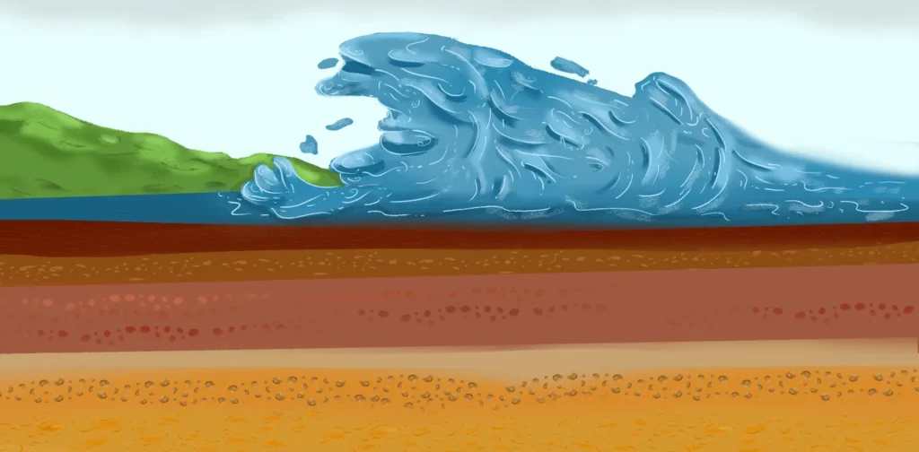
Illustration by Irhan Prabasukma
Where we are influences how we live; so, having as much information as possible on the land we live in is crucial. Indonesia’s unique geological setting as an archipelago on the Ring of Fire makes it highly vulnerable to natural disasters, such as volcanic eruptions, earthquakes, and tsunamis. Effective management of these geohazards requires utilization of subsurface data, yet accessing such data remains challenging.
Geohazards Beneath the Sea
In 2018, the eruption and partial collapse of small volcanic island Anak Krakatau’s flank triggered a devastating tsunami in the Sunda Strait, tragically confirming what scientists had long cautioned.
In a 2012 study, researchers warned that a 0.28 cubic kilometer (km³) submarine landslide could generate a tsunami that reached the beautiful beaches of Anyer and Carita within 35–45 minutes. The actual event was even more devastating. A smaller submarine landslide (~0.1 km³) produced a larger and faster tsunami than previously modeled.
Later, research in the Makassar Strait using seismic reflection data—a type of subsurface data that functions like an X-ray of the Earth—has revealed the presence of massive submarine landslides measuring approximately 600 km³, 2,500 times larger than the landslide at Anak Krakatau.
If a similar submarine landslide were to recur, it could generate a tsunami that may impact the eastern coast of Kalimantan, including Nusantara, Indonesia’s new capital currently under construction.
Thus, the urgency to study and mitigate such risks across Indonesia—as a maritime country with the second longest coastline—cannot be overstated.
Why Subsurface Data Matters
Subsurface data has been widely used by the oil and gas industry for decades. To put it simply, subsurface data refers to information about and collected from beneath the Earth’s surface. This data is primarily acquired by oil companies for petroleum exploration and production. However, access to this kind of data has long remained exclusive.
Beyond petroleum, subsurface data enables informed decisions for sustainability and resilience. The benefits range from identifying geological hazards and assessing carbon capture storage (CCS) sites to supporting marine conservation and climate adaptation strategies.
Yet, non-commercial research—like geohazard studies—often lacks funding, relying mostly on limited grants and government support. This makes it harder to plan for and reduce disaster risks. In fact, existing subsurface data could play a key role in solving this problem.
Indonesia’s Progress and Global Lessons
In recent years, Indonesia has made progress in improving accessibility to subsurface data through the establishment of the Migas Data Repository (MDR). Although it is a significant step toward transparency and accessibility, the system has too many barriers. It is subscription-based and lacks ease of use. Moreover, the procedure for non-commercial research access remains complicated.
While there is a lot to improve, there is also much to learn from. The concept of open access subsurface data is not new. Many countries, such as Australia with NOPIMS (National Offshore Petroleum Information Management System) and Norway with Diskos National Data Repository, have already implemented policies that make subsurface datasets widely available for both research and industry applications.
These systems not only provide open access to data but also feature user-friendly interfaces, making them as easy to navigate as an online marketplace. By adopting a similar approach, Indonesia could significantly expand the reach and impact of its subsurface data.
Subsurface Data: From Science to Policy
Sustainable development depends heavily on science, especially when it comes to turning research into an effective policy. Understanding past submarine landslides is just as important as predicting future ones—like the tsunami triggered by Anak Krakatau.
For instance, in 1969, a tsunami struck the west coast of Sulawesi, killing at least 600 people and leveling homes. It was linked to a magnitude 7.0 earthquake, but recent research showed the quake alone could not explain the scale of destruction. A nearby submarine landslide—known as the Haya Slide, identified through seismic reflection data—likely played a key role.
This example reveals how hidden hazards beneath the seafloor can silently worsen disasters. Without timely action, vulnerable coastal communities remain at risk worse than they have to be.
By incorporating insights from subsurface data into geohazard models, the government can deliver more accurate risk assessments, design better emergency response plans, and shape smarter land-use policies—especially in high-risk coastal zones.
Democratizing Access to Subsurface Data
To fully harness the value of subsurface data, Indonesia should prioritize democratizing petroleum-related datasets while respecting data ownership. Countries like Australia and Norway have shown that it is possible to broaden access without compromising commercial confidentiality.
Policies that grant user-friendly, low-barrier access to data for universities, non-commercial researchers, and other stakeholders could unlock new innovations in disaster mitigation, climate adaptation, and resource management. Streamlining the process by reducing bureaucracy is key.
Furthermore, integrating subsurface data into national planning can reshape how the country approaches sustainability challenges. Expanding access to these often-hidden data sets can drive smarter, evidence-based decision-making. When researchers, policymakers, and the public can explore and use subsurface insights, the nation gains powerful tools for managing both natural hazards and resources more effectively. Greater collaboration between government, academia, and industry is essential.
Ultimately, democratizing access to geological data will help Indonesia develop solutions tailored to its unique geography—strengthening resilience, improving safety, and supporting a more sustainable future for all.
Editor: Nazalea Kusuma
Co-create positive impact for people and the planet.
Amidst today’s increasingly complex global challenges, equipping yourself, team, and communities with interdisciplinary and cross-sectoral insights on sustainability-related issues and sustainable development is no longer optional — it is a strategic necessity to stay ahead and stay relevant.
Harya Nugraha
Harya is an Assistant Professor and the Head of Center for Sustainable Geoscience and Outreach (CSGO) at Universitas Pertamina. He is also a Researcher at the University of Bergen. He specializes in using subsurface data for sustainability and holds degrees from Imperial College London and ITB. He is also a member of the Indonesian Society of Sustainability Professionals (IS2P).
Rizky Amanda
Rizky is a geologist and strategist at Equinor, Norway, focusing on supporting the company to navigate through the energy transition. He holds an MBA from BI Norwegian Business School, an MSc from the University of Stavanger, and a BSc in Geological Engineering from ITB.
 The Invisible Infrastructure: What ASEAN’s Carbon Market Needs Most
  Indonesia Ruled to Recognize Chronic Illness as a Disability
  Clean Cooking as a Developmental Multiplier in Africa
  Congo Basin Peatlands Are Releasing Ancient Carbon
  From Anxiety to Action: How Youth Climate Activism Is Evolving
  India’s Supreme Court Declared Menstrual Health and Hygiene as Fundamental Rights