A New Interactive Map for New Zealand’s Biodiversity Restoration
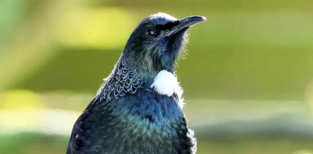
The tūī bird, a native species to New Zealand. | Photo: Andrea Lightfoot on Unsplash.
New Zealand is home to approximately 80,000 species of endemic biodiversity. Unfortunately, the number of these native species has been gradually shrinking due to pressure from invasive species, human activities, and climate change. On top of that, minimal data and information also hinder the conservation process. New Zealand’s BioHeritage National Science Challenge launched an interactive map to understand New Zealand’s biodiversity condition better.
New Zealand’s Biodiversity
One-third of New Zealand’s biodiversity species are listed as threatened and at risk. For instance, data from New Zealand’s Department of Conservation shows that 71 bird species were listed as threatened, and 107 were at risk out of 487 taxa examined. This includes native birds kākāpō (Strigops habroptilus) and kea (Nestor notabilis). Land use change, high levels of water pollution, and predatory species contributed to New Zealand’s decline in biodiversity.
Implementing practical conservation efforts requires a thorough understanding of biodiversity’s condition. In this case, assessment and updated data become crucial tools. However, data gaps remain for New Zealand’s biodiversity, with roughly one-third of named species still listed as data deficient. The Ecosystem Restoration Map launched by Eco-index aims to bridge this gap.
Eco-index Interactive Map
Eco-index is a research program under New Zealand’s BioHeritage National Science Challenge. The program aims to address Aotearoa New Zealand’s biodiversity decline by enhancing efforts and coordination to protect, restore, and connect native ecosystems.
Under the program, researchers and scientists developed an interactive map with inputs from relevant stakeholders, including Indigenous leaders, council representatives, and industry advocacy groups. The Ecosystem Restoration Map contains information on the natural range of areas where a species has naturally lived and the restoration priority areas where local biodiversity is most at risk. The goal is to achieve a minimum land coverage of 15% of each native ecosystem in the country.
“In science, it is known that the game changes for biodiversity if we can safeguard at least 15% of the expected natural range of each native ecosystem,” said Dr Kiri Joy Wallace, co-lead of Eco-index. “In some areas, reaching 15% requires complete reconstruction of native ecosystems through ecological restoration efforts like tree planting and non-native species removal. In areas where 15% native land cover already exists, protecting those existing ecosystems is key.”
Bridging the Information Gap
The Ecosystem Restoration Map supports national efforts and policies to safeguard Indigenous Biodiversity. It invites the government, businesses, Indigenous communities, and other relevant stakeholders to better understand New Zealand’s biodiversity condition by enabling them to share information on every ecosystem in every catchment of the country. The map also hopes to bridge the information gap surrounding biodiversity in New Zealand.
“At a national level, there are challenges around biodiversity data collection, access, and sharing,” said Sam Rowland, Programme Manager – Nature, Systems Change at the Sustainable Business Network and co-chair of the Eastern Whio Link. “This map is a good start at fixing those issues, and we’re excited to utilize this information for biodiversity strategies and planning.”
Editor: Nazalea Kusuma
Join Green Network Asia Membership
Amidst today’s increasingly complex global challenges, equipping yourself, team, and communities with interdisciplinary and cross-sectoral insights on sustainability-related issues and sustainable development is no longer optional — it is a strategic necessity to stay ahead and stay relevant.

Kresentia Madina
Madina is the Assistant Manager of Stakeholder Engagement at Green Network Asia. She holds a bachelor’s degree in English Studies from Universitas Indonesia. As part of the GNA In-House Team, she supports the organization's multi-stakeholder engagement across international organizations, governments, businesses, civil society, and grassroots communities through digital publications, events, capacity building, and research.


 Exploring Technological Advancement to Replace Animal Testing
  Addressing Overconsumption for Transformational Changes
  Global Reform on Fisheries Subsidies Signals a Hopeful Shift Toward Ocean Sustainability
  A Major Cause of Changing Rainfall Patterns
  Strengthening Disaster Risk Governance at Local Levels
  Recognizing the Role of Local Communities in Biodiversity Conservation